Dr.
Harry Williams
Professor
Department of Geography
University of North Texas
1155 Union Circle, #305279
Denton, TX 76203, USA
Phone: (940) 565-3317
Fax: (940) 369-7550
E-mail: HarryF.Williams@unt.edu
Harry Williams CV
Faculty Profile System
Harry Williams
UNT Geography
UNT
Professor
Department of Geography
University of North Texas
1155 Union Circle, #305279
Denton, TX 76203, USA
Chair, Coastal and Marine Specialty Group,
Association of
American Geographers
Editorial Board Member, Journal of Coastal Research
Phone: (940) 565-3317
Fax: (940) 369-7550
E-mail: HarryF.Williams@unt.edu
Harry Williams CV
Faculty Profile System
Harry Williams
UNT Geography
UNT
| About me | Research | Courses | Students | Publications |
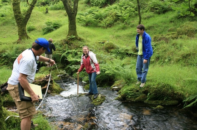
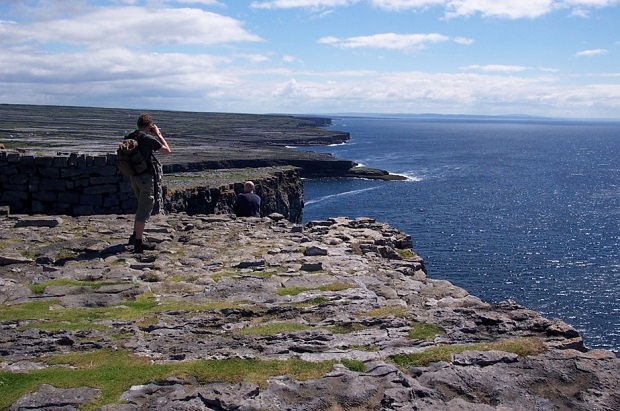
The British Isles Field School: measuring stream morphology on Dartmoor near Plymouth; free day trip to the Isle of Inishmor, off the northwest coast of Ireland.
Course Web Pages:
1. Geology 1610 Physical Geology: physical geology is the study of the rocks that form the crust of the Earth. Topics include: the nature and origin of crustal rocks; surface processes, such as rivers and waves that shape rocks into specific landforms; plate tectonics - a theory that has revolutionized geology in the last few decades and explains the occurrence of mountains, earthquakes and volcanoes.
2. Geography 1710 Earth Science: a broad introduction to the study of the physical characteristics of the surface of the earth. It includes the lithosphere (rocks, soil), atmosphere, hydrosphere (oceans, lakes, rivers, rainfall) and biosphere (plants and animals). The first part of the course deals mainly with weather and climate. The second part concerns geology and landforms of rivers, deserts and coasts.
3. Geology 3020 Historical Geology: the study of the evolution of landforms and life-forms through geologic time. Geologic features such as rock types and fossils are used to interpret and date past events. The first third of the course introduces the basic geologic principles underlying historical geology; the second two thirds of the course focus on the geologic evolution of the North American continent and the evolution of life on Earth.
4. Geography 4030 British Isles Field School: this 3-week course gives students direct experience in applying geographical field techniques in a foreign setting - the British Isles and Ireland. The field school will be centered on five base sites - Plymouth, Cork, Galway, Bangor and Edinburgh. At each site, students will conduct one-day human and physical geography field exercises, designed to provide training in various field techniques.
5. Geography 4050 Introduction to Cartography: an introductory-level course in cartography. Course topics include the theory of map projections; the construction and interpretation of topographic maps that show the shape of the Earth's surface; the use of thematic maps to portray various types of geographically-referenced data; a brief introduction to GIS, surveying and GPS mapping.
6. Geography 4060 Applied GIS: MapInfo: this course focuses on hands‑on experience using MapInfo GIS software to produce maps. Topics include: map editing; editing map attribute databases; map design and printing; data sources; importation of databases; geocoding; applications.
7. Geography 4350 Geomorphology: the study of the landforms that make up the surface of the Earth. The organization of the course reflects the 4 main controls on landform development: large scale geologic structures; lithology; erosional and depositional processes; influence of past events. The final three lectures cover a selection of applied geomorphology topics.