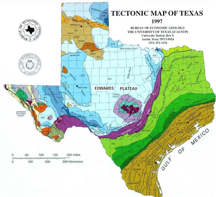
Figure 1. Tectonic Map of Texas.
LAB 1. TECTONIC STRUCTURES OF TEXAS
The purpose of this lab is to build on the material on global geomorphology covered in the last lecture and to provide examples of large-scale tectonically-influenced regions in Texas. The lecture illustrated that continents have "global-scale" tectonic regions, such as orogenic belts, coastal plains and basins and domes. In this lab, we focus down to a smaller area - the State of Texas (still pretty big!). Texas also has large-scale tectonic regions that create landscapes with distinctive geomorphology - compare, for example, mountainous far-west Texas (part of an orogenic belt) with the flat, low-lying area around Houston (part of a passive margin coastal plain).
This lab introduces the large-scale tectonic structures of Texas by examining aspects of the geological evolution of the state over time, from the Precambrian (approximately 1.1 billion years ago) to the present-day.
Figure 1. Tectonic Map of Texas.
The Llano Uplift (find this
feature on Figure 1).
Old cratonic rocks of the North American craton are exposed in only a
few places
in Texas. The most prominent, and a dominant geologic feature of the
state, is
the Llano Uplift in the center of the Texas Hill Country (Fig.
1). The uplift is equivalent
to a dome (part of the craton that is high enough to stick up through
surrounding platform rocks). Part of the Llano
Uplift forms Enchanted Rock - a granite exfoliation dome (Fig. 2).
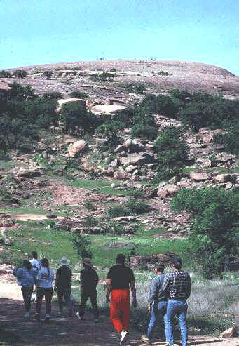
Figure 2. Enchanted Rock. This
Precambrian (Before the Cambrian Time Period or before ~542 million
years ago) granite (1.1 billion years
old) is part of the North American craton exposed in the Llano
Uplift (see people on top for scale).
It appears that the craton is thicker here than in the surrounding region. This is why this part of the state is an "uplift" (the thicker continental crust "floats" higher on the underlying mantle).
The Ouachita Tectonic Front (find this feature on Figure 1).
The Ouachita Tectonic Front is an orogenic belt formed during the
Ouachita
Orogeny (an orogeny is a period during which orogenesis occurred; Fig.
1). This orogeny resulted from the collision of North America and
South America in the late Paleozoic Era (about 290 million years ago).
The
collision formed a large mountain chain along the southern margin of
North
America (Fig. 3).
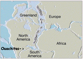
Figure 3. The collision of North America and
South America about 290 million years ago.
Although much of these mountains are now eroded and buried, remnants form the Ouachita Mountains of Arkansas/Oklahoma and the Marathon Mountains of Texas (Fig.4).
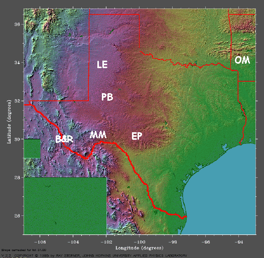
Figure 4. Shaded Relief Image of Texas. OM: Ouachita Mountains; MM:
Marathon
Mountains; EP: Edwards Plateau; B&R: Basin and Range; PB: Permian
Basin; LE:
Llano Estacado
The Balcones Escarpment (coincides with the Balcones Fault Zone - find this feature on Figure 1).
The Balcones Escarpment (a relatively steep "step" in the
landscape) marks the line of contact between North and South
America during the Ouachita
Orogeny. The Balcones
Escarpment separates the
uplifted region to the northwest of
the Balcones Fault Zone from the subsided region to the southeast (Fig.
1).
Vertical displacement between these two regions has occurred along a
series of
high-angle normal faults that probably formed during the Ouachita
Orogeny, the
rifting of North and South America following the orogeny and subsidence
of the
Gulf Coastal Plain due to sediment loading. In general, rocks to the
northwest
of the escarpment are more resistant to erosion than rocks to the
southeast and
so differential erosion also has played a role in creating about 300
feet of
elevation change across the escarpment (Fig. 5).
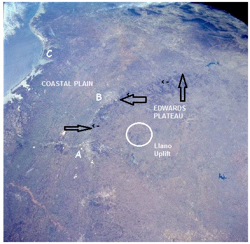
Figure 5. Satellite view to the southwest across Texas, showing Austin (A) and San Antonio (B) at the base of the Balcones Escarpment (arrowed). Corpus Christi is seen in the distance (C).
The Edwards Plateau (find this feature on Figures 1, 4, 5 & 6).
The Edwards Plateau (Fig. 4) is a platform region capped by hard
Cretaceous (~100 million years old) limestones. Some
of the relief of this region is due to uplift along the Balcones Fault
Zone,
some is due to the resistance of the limestones to erosion (Fig. 6).
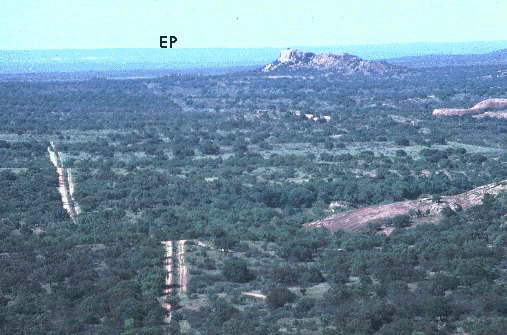
Figure 6. View from the top of Enchanted Rock. Llano Uplift Precambrian granite outcrops are
seen to the right; the far horizon (EP) is the edge of the Edwards
Plateau
(Note: cratonic rocks of the Llano Uplift are exposed in a topographic
basin within the Edwards
Plateau).
The Permian Basin (find this feature on Figure 4).
During the Permian Period, about 280 million years ago, the
Ouachita
mountains bordered the eastern margin of several inland marine
basins, including the Midland, Delaware, and Val Verde
basins (see Figure 1 for the locations of these basins), which now
collectively compose the oil-rich Permian
Basin of West Texas (Fig. 4, PB; Fig. 7). These basins filled with
marine, fluvial,
deltaic and
evaporite deposits, including gypsum, forming layers of sedimentary
rocks that cover the craton in this area and also make this a platform
region (Fig. 8).
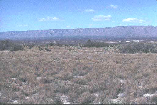
Figure 7. View of the Guadalupe Mountains on the
Texas/New Mexico border from the Permian Basin. The mountains are a
fringing
limestone reef that surrounded an inland sea.
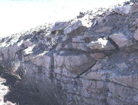
Figure 8. Road cut exposing gypsum deposits in the
Delaware Basin. Gypsum is an evaporite, formed by evaporation of sea
water under a hot climate and usually where water circulation is
restricted - for example, where mountains partially enclose an inland
sea (these conditions existed in this part of Texas during the Permian Period).
The Basin and Range (find this feature on Figure 4).
Far west Texas lies in the Basin and Range Province of western
North
America. This region (Fig. 4, B&R) is part of the Laramide Tectonic
Front (an orogenic belt).
This orogeny, resulting from plate convergence along the western margin
of North
America, formed many of the major structures of the Rocky Mountains
during the
early Paleogene Period (30-60 million years ago). Orogenic activity
also led to
the emplacement of many volcanic rocks in the Big Bend region and the
formation
of numerous faults - movement along these faults created the basin and
range
topography (Fig. 9).
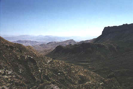
Figure 9. Numerous fault-block ranges (uplands) in Big Bend National
Park.
Llano Estacado (find this feature on Figure 4).
During the middle to late Cenozoic Era (5-30 million years ago),
streams originating in the recently elevated Rocky Mountains to the
west transported large
volumes of sand and gravel into the Texas Panhandle, which accumulated
in large alluvial
fans - an example of backarc basin sedimentation. These deposits form
the
Southern High Plains (Llano Estacado) - a nearly flat plateau with an
average elevation approximating 3,000
feet (Fig. 4, LE). Between 5 and 10 million years ago, the sediment
supply was
cut off due to regional uplift in the west and the eastern edge of the
plains began to retreat westward as rivers draining into the Gulf of
Mexico caused headward
erosion, as exemplified by Palo Duro Canyon (Fig. 10). The resulting
escarpment
(the steep cliff at the edge of the plateau) that extends in a north-south line in West Texas and the Panhandle is
the
Caprock Escarpment (Fig. 11). To the west, the Llano Estacado is
bounded by the Mescalero
escarpment, overlooking the Pecos Valley (Fig. 12).
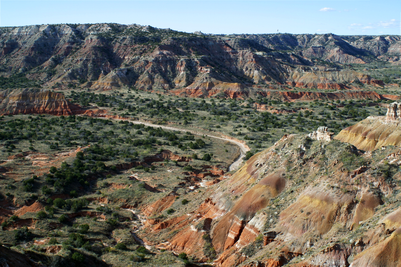
Figure 10. Palo Duro Canyon, carved by headward erosion of rivers cutting back into the Llano Estacado.
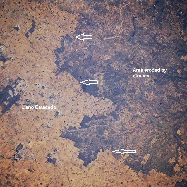
Figure 11. The Caprock Escarpment in the Texas Panhandle (arrowed). The Llano Estacado lies to the left (west), numerous canyons and gullies mark the Caprock Escarpment and the eroded plains to the right (east).
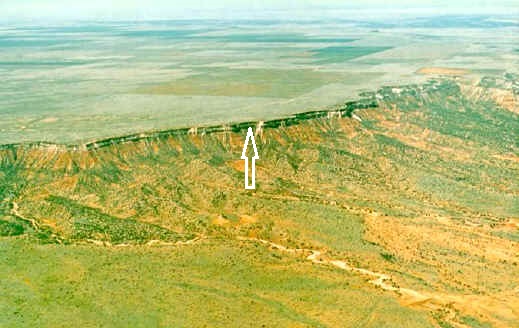
Figure 12. The Mascalero Escarpment
(arrowed) on the western edge of the Llano Estacado in
New Mexico (the Caprock Escarpment is a similar feature).
The Gulf Coastal Plain.
The Gulf Coastal Plain (Fig. 1) consists mainly of Cenozoic
(post-65 million years ago) clastics (mud
and sand) and is an example of passive margin sedimentation. Numerous
faults
parallel the coast, formed partly by rifting as North and South America
separated after the Ouachita Orogeny, partly by Cenozoic sediment
loading (Fig.
13).
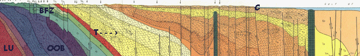
Figure 13. Cross section of south Texas from the
Llano Uplift to the Gulf of Mexico. LU: Llano Uplift; OOB: Ouachita
Orogenic
Belt; BFZ: Balcones Fault Zone; T--->: Base of Cenozoic
sedimentation; C:
coastline. Numerous high-angle faults cut the section (lines with
arrows). Green
columns are salt domes.