Stream Valleys
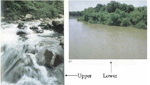
Generally speaking, it is true that river valleys in upper reaches tend to be narrow and steep, while in lower reaches valleys are wider and have more gentle slopes. The steeper slopes in upper reaches promote vertical and headward erosion, rather than lateral erosion. The exact shape of the valley is also determined by mass wasting, which depends on hillslope processes and rock strength.
In lower reaches, 2 important changes usually occur - the river becomes an alluvial channel (flows through its own alluvium); and the channel has a greater tendency to erode laterally, leading to a wider, flat bottomed valley.
Middle reaches - streams begins to erode laterally, carving out a wide flat floodplain, filled with alluvium (stream sediment). More meandering, gentler slopes.
Lower reaches - floodplain wider, more meandering, gentler slopes.
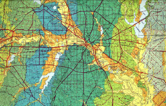
The width of the valley created is dependent on the resistance of the surrounding rock to lateral erosion - so different rock types undergo differential lateral erosion (e.g. compare the valley width in Austin Chalk, Eagle Ford Shale, Taylor Marl in Dallas).
Channel Long Profiles
Recap: streams are steep in their upper reaches, more gently sloping in their
lower reaches...
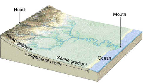
So, streams naturally tend to develop concave-upward long profiles - this comes about because of the need to balance the transporting ability of the river and the input of sediment i.e.:
1. in the upper reaches of a network, discharge is low and sediment is coarse - therefore steep slopes are required to give the river sufficient energy to transport the sediment (if the slope was too low, sediment supplied by mass wasting would build up the bed of the channel and increase the slope: if the slope was too steep, the excess energy would erode the bed, lowering the slope and causing headward erosion).
2. in the lower reaches of a network, discharge is high and sediment is finer (because of abrasion) - therefore gentle slopes are sufficient to give the river enough energy to transport the sediment.
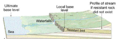
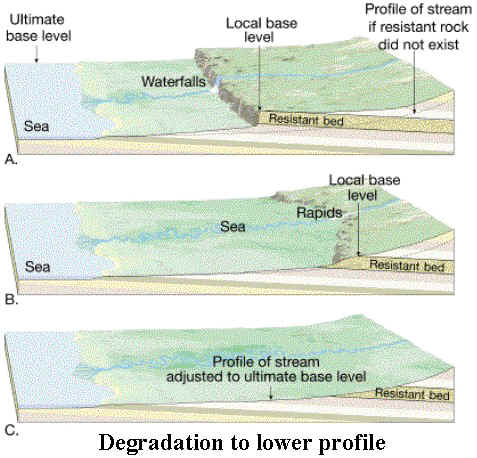
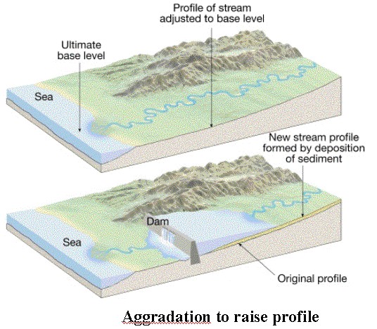
The bottom of the profile is aligned to the stream's BASE LEVEL (the level to which the stream erodes down to, but no lower). For many large rivers, the ocean represents base level, but for smaller streams - lakes, larger streams, resistant rock outcrops can all act as LOCAL BASE LEVELS. In reality, of course, the smooth concave profile is rarely achieved: irregularities such as resistant rock outcrops result in a "step" in the profile, marked by waterfalls or rapids.
Streams will try to adjust their long profile until the smooth concave shape is achieved. The bed of a stream can be lowered by erosion or raised by deposition. These processes are known as DEGRADATION and AGGRADATION respectively.
These processes also operate over the short term in response to precipitation inputs (i.e. a large storm causes sediment to be eroded from the channel bed and then deposited again when the storm ends and flow decreases).
Movement of sediment through a river system therefore tends to be discontinuous - the sediment is stored within the river system between storms that are big enough to cause the sediment to be re-entrained and moved further downstream - in many systems, it can take hundreds or thousands of years for sediment to move all the way through. Over the long term however, if as much sediment as is supplied can be moved through, the river is said to be graded (i.e. there is a balance between input and output of sediment to the river system), and the shape of the channel over the long-term may remain essentially unchanged (a graded long profile).
For this reason, many channels flow through their own deposits - these are ALLUVIAL CHANNELS. These occur particularly in lower reaches where deposition is more likely to occur; in the upper reaches channels may be cut directly into the underlying rock, forming BEDROCK CHANNELS.
Example Question:
1. Explain the
connection between the following concepts: channel long profile; base level;
aggradation; degradation; alluvial channel; bedrock channel.
Back
to review index.