HYDROLOGICAL CYCLE AND HILLSLOPES
Introduction Outside of river channels where fluvial processes operate, all land surfaces can be considered HILLSLOPES (completely flat areas are very rare, and even they can be considered hill slopes with a slope of 0o). The erosion of hill slopes in most areas can be considered a system which links together WEATHERING (breaks down rock in situ), HILLSLOPE PROCESSES (mass wasting - material - solid rock, regolith, soil - is moved down slope either by gravity or by running water) and EROSION (usually by rivers in valley bottoms).
The Role Of Water
In Hillslope Erosion (see Fig. 8.1 in text for diagram of small drainage basin
hydrology).
Most rain falls onto the valley sides. Whether or not the water infiltrates
depends on 2 factors:
1. the infiltration capacity of the surface = rate of infiltration allowed by
surface (depends on surface conditions).
2. rainfall intensity (e.g. inches per hour).
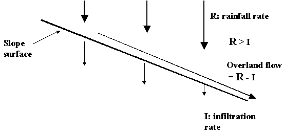
OVERLAND FLOWS:
where the rainfall intensity exceeds the infiltration capacity, HORTONIAN
OVERLAND FLOW results.
SATURATION OVERLAND FLOW occurs mainly at the base of slopes and in concavities, which become saturated during prolonged rain (by the combination of infiltration, interflow (flow down slope within the soil) and groundwater flow - once the soil is saturated its infiltration capacity is zero, so any additional rain will not infiltrate - it be will stored on the surface or become overland flow.
Subsurface Flows
Water that INFILTRATES the ground becomes either SOIL MOISTURE (films clinging
to particles in the AERATION ZONE) or GROUNDWATER (the SATURATED ZONE, the top
of which is THE WATER TABLE). Just above the water table there is the CAPILLARY
FRINGE where water is drawn up from the water table by capillary action ->
discontinuous saturation.
The water table is not level, it follows the shape of the surface - higher under
hills, lower in valleys; because of this, both soil moisture and groundwater can
flow from high elevation to lower elevations - down slope as interflow and
groundwater flow.
These subsurface flows are usually very slow - a typical flow rate for clean sand is around 10 m/day; their main contribution to hill slope erosion is the removal of material in SOLUTION eg
Rock Type Ground Lowering (mm/1000 years)
Igneous/metamorphic 0.5 - 7.0
Recent (Tertiary) sandstone 16 - 34
Limestone 22 - 100
AND, their contribution to SATURATION OVERLAND FLOW...
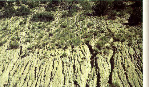
Overland Flows & Erosion. Hortonian and saturation overland flows move sediment down slope. This results in sheetwash, rills and gullies. Definitions: sheetwash = sheet of water flowing across surface; rills = sheetwash concentrates into small channels; gullies = sheetwash and/or rills concentrate into larger channels on hill slopes. Sheetwash is aided by rain splash erosion - raindrops detach particles from the surface - most effective in dry regions which lack protective vegetation. In all cases, the movement of soil and rock particles by flowing water is EROSION.
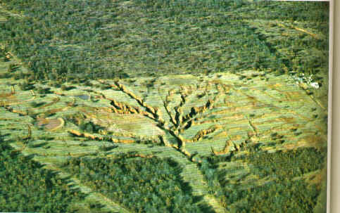
Rills formed from concentrated sheetflow (below); further surface flow concentration results in gullies. Cultivation disturbs the surface, can lower infiltration and promote overland flow and gullying (2nd image below).
In this region, Hortonian overland flows do occur - especially on Woodbine sandstone during intense rainstorms. Very intense rain may only last a few minutes, but a lot of erosion can occur.
Significant overland flows occur where infiltration is low and rainfall intensity is high. Infiltration is affected greatly by the presence of vegetation, which promotes infiltration by maintaining an open soil structure. For this reason, Hortonian overland flows occur mainly in arid regions with poor vegetation cover, which are subject to rare but intense thunderstorms. eg. Big Bend area, West Texas, Southwest U.S.
In humid vegetated regions, overland flow is less common, except where the surface vegetation is disturbed (e.g. construction, fire, cultivation, compaction…. etc).
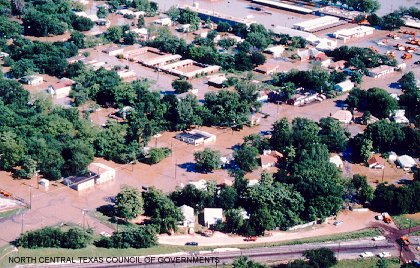
Another exception would be urbanized areas. Concrete has effectively zero infiltration. It generates Hortonian overland flows that drain rapidly into storm sewer systems. These in turn feed the water very quickly into local streams. The result is that floods may be more likely following urbanization of a watershed, unless there is adequate protection by levees, retention ponds and/or other flood control structures.
If flood protection is inadequate, flooding usually occurs downstream from the main urban area - e.g. Rochester Park).
Example Questions:
1. Draw a labeled sketch of small drainage basin hydrology. Identify and describe each component.
2. Explain, using diagrams, Hortonian overland flow, saturation overland flow and interflow.
3. With reference to the article on the effects of urbanization on White Rock Creek, describe a. the hypothesis, b. the methods and c. the results of the study.
5. Give examples of how a). disturbance and b). urbanization causes Hortonian overland flows.