GLACIAL LANDSCAPES
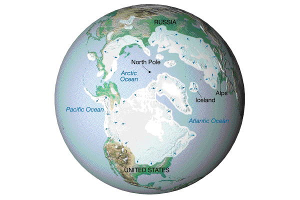
The Quaternary Period is divided into 2 epochs - the Pleistocene (1.6 mybp - 10,000 ybp) and the Holocene (10,000 ybp - present). The Pleistocene was a time of fluctuating colder climates that resulted in a number of extensive glaciations or ICE AGES. At present, ice covers about 10% of the land surface, whereas at its maximum extent during the Pleistocene it covered about 30%.
In the study of landforms, Pleistocene glaciation is important since many areas glaciated in the Pleistocene are still dominated by glacial landforms today, even 10,000 years after the last Ice Age ended. The reason for this is that glaciers are capable of massive erosion and deposition and leave a long-lasting imprint on the local geomorphology. If you visit the northern states, or other glaciated regions, the only way to understand the local geomorphology is to recognize that these are glacial landscapes.
In North America, two distinct types of
glaciation occurred:
ALPINE GLACIATION, characterized by valley glaciers, in mountainous areas of the
western U.S.; and CONTINENTAL GLACIATION, characterized by large unconfined ice
sheets, over much of Canada and the northern states.
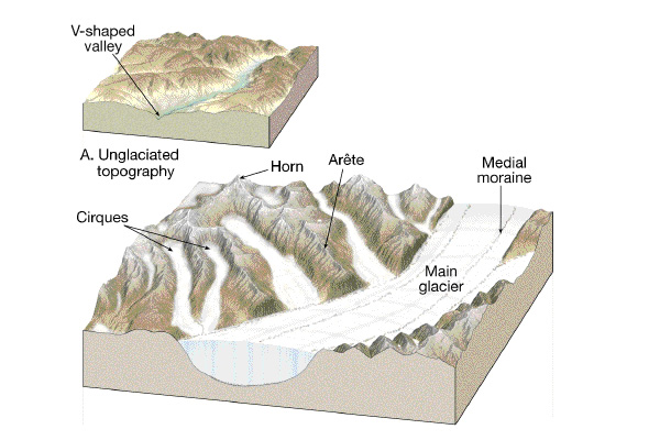
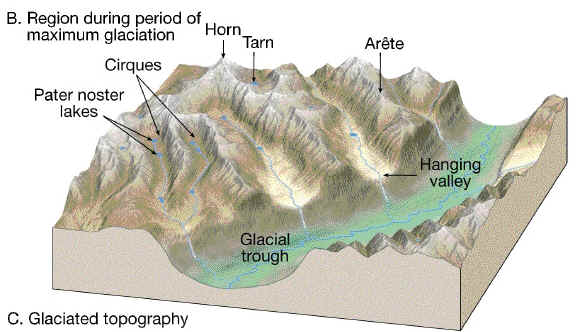
Landforms of Alpine Glaciation
EROSION is the dominant process in glaciated mountainous regions. The glaciers are confined to pre-existing steep valleys and tend to erode vertically. Wide U-shaped glacial troughs, hanging valleys, horns, cirques, aretes and truncated spurs are the result.
Landforms of Continental Glaciation.
DEPOSITION is dominant in lowland areas at the margins of continental
glaciers - the northern states in North America. This is where debris carried in
the ice is released as the ice melts. Further back from the ice front, (mainly
in Canada) erosion can occur by SCOURING of the surface by debris (rocks)
carried at the base of the ice. General scouring of the surface removed much
topsoil from these areas, which is slow to recover due to the cold climates.
Scouring also creates small grooves or striations or lager troughs aligned with
the direction of ice flow; many larger troughs filled with water to become
lakes.
Much of the landscape of the northern mid-west is dominated by depositional landforms. Deposition can occur directly from the ice - erratics, ground moraine, drumlins, end moraines - or from meltwater (mainly gravel, sand, mud) in the form of lake deposits, outwash (melt-water stream) deposits and eskers (sub-glacial melt-water deposits).
Outwash is sand and gravel deposited by meltwater streams that form in the summer. These streams are typically braided and create wide outwash plains. Outwash can extend 10’s of miles beyond the margin of an ice sheet. Outwash sediment has the character of alluvium (well-sorted, stratified).
Summary: glaciers and ice sheets cause massive erosion and deposition. They create long-lasting erosional and depositional landforms. Glacial features dominate landscapes in the northern states and Canada, even though they were formed more than 10,000 years ago. In mountainous regions, glaciers are confined to valleys, concentrating their erosion. Consequently, EROSIONAL landforms dominate - there is relatively little deposition and few depositional features. In lowland regions, large unconfined ice sheets cause general scouring of the surface, while DEPOSITIONAL features dominate marginal areas (near the ice front). Deposition can be directly from the ice (ice-contact deposits, including ground moraine, drumlins, end moraine and eskers) or can be meltwater deposits (outwash plains) extending beyond the ice limits.
Example Questions:
1. Describe the major contrasts between landscapes of alpine glaciation and landscapes of continental glaciation (include typical glacial landforms in your answer).